Brighton Antique Prints and Maps
Currency
WOOCS 2.1.5
VIEW CART
  • CURRENCY

    WOOCS 2.1.5
  • Home
  • Catalogue
    • Antique Maps
    • Antique Prints
    • Books & Gov’t Reports
    • Manuscript Documents
  • Recent Arrivals
  • About
  • FAQ
  • Register Interests
  • Contact Us
4-032 – Britannicae Insule de Vaugondy – circa 1757 Copperplate engraving 53cm X49cm Condition A

Home/Antique Maps/Britain and Ireland/Britain

Antique Map 4-032 – Britannicae Insule de Vaugondy – circa 1757 Copperplate engraving 53cm X49cm Condition A

SKU: 4-032 Categories: Antique Maps, Britain
4-168  England and Wales  c.1844
14-210 - Victoria - Portland district Admiralty Chart - circa 1835 Steel engraving 46cm X 63cm Condition A+
  • Description

Britannicae Insule

de Vaugondy – circa 1757
Copperplate engraving
53cm X49cm
Condition A

SOLD


These may also be of interest

  • 4-188 Somersethire England by I. Slater c.1847
    Antique Maps

    Antique Map 4-188 Somersethire England by I. Slater c.1846

    $195.00
  • 4-162 - England - Lincolnshire Moule - circa 1840 Hand coloured steel engraving 19cm X 26cm Condition A+
    Antique Maps

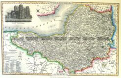
    Antique Map 4-162 – England – Lincolnshire Moule – circa 1840 Hand coloured steel engraving 19cm X 26cm Condition A+

    $240.00
  • Antique Maps

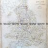
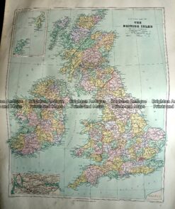
    Antique Map 233-289 Britain – County map by Stanford c.1887

    $140.00
  • 4-140 - England and Wales George Virtue - circa 1840 Hand coloured steel engraving 20cm X 25cm Condition A+
    Antique Maps

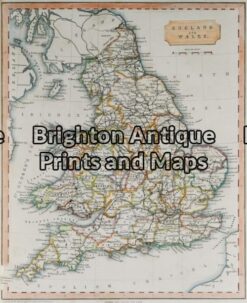
    Antique Map 4-140 – England and Wales George Virtue – circa 1840 Hand coloured steel engraving 20cm X 25cm Condition A+

    $140.00
© 2026 BRIGHTON ANTIQUE PRINTS AND MAPS. ALL RIGHTS RESERVED | Website by Blaze Online
Credit Card
Norton Safe Web Transaction
  • Home
  • Catalogue
    • Antique Maps
    • Antique Prints
    • Books & Gov’t Reports
    • Manuscript Documents
  • Recent Arrivals
  • About
  • FAQ
  • Register Interests
  • Contact Us
  • View Cart
  • Login
  • Currency
    WOOCS 2.1.5

Sending...