Brighton Antique Prints and Maps
Currency
WOOCS 2.1.5
VIEW CART
  • CURRENCY

    WOOCS 2.1.5
  • Home
  • Catalogue
    • Antique Maps
    • Antique Prints
    • Books & Gov’t Reports
    • Manuscript Documents
  • Recent Arrivals
  • About
  • FAQ
  • Register Interests
  • Contact Us
3-790 Australia by Wilkinson

Home/Antique Maps/Australia & Pacific/Australia - Continent

Antique Map 3-790 Australia by Wilkinson

SKU: 3-790 Categories: Antique Maps, Australia - Continent
3-805 County of Cumberland NSW by Basch circa 1872
3-022 - Australia - East Coast of Australia from Cooks first voyage Dutch edition van Baasel - circa 1774 Copperplate engraving with outline colour 78cm X 36cm Condition A+
  • Description

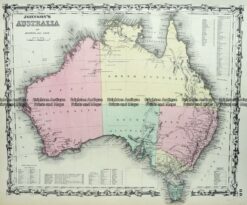
3-790 &;New South Wales & Norfolk Island

Wilkinson, R &;circa 1794
Hand coloured copperplate engraving
23cm X 28cm
Condition A+

SOLD


These may also be of interest

  • 3-515  Australia by Johnson  c.1855
    Antique Maps

    Antique Map 3-515 Australia by Johnson c.1855

    $290.00
  • 3-104 - Western Australia - Sharks Bay area J Sands - circa 1886 Chromolithograph 52cm X 42cm Condition A+
    Antique Maps

    Antique Map 3-104 – Western Australia – Sharks Bay area J Sands – circa 1886 Chromolithograph 52cm X 42cm Condition A+

    $250.00
  • Australia - Continent

    Antique Map – Oceanique Orient by Tardieu c.1812 Ref: 237-153

    $400.00
  • 3-083 - Northern Territory J Bartholomew - circa 1880 Chromolithograph 23cm X 32cm Condition A+
    Antique Maps

    Antique Map 3-083 – Northern Territory J Bartholomew – circa 1880 Chromolithograph 23cm X 32cm Condition A+

    $75.00
© 2026 BRIGHTON ANTIQUE PRINTS AND MAPS. ALL RIGHTS RESERVED | Website by Blaze Online
Credit Card
Norton Safe Web Transaction
  • Home
  • Catalogue
    • Antique Maps
    • Antique Prints
    • Books & Gov’t Reports
    • Manuscript Documents
  • Recent Arrivals
  • About
  • FAQ
  • Register Interests
  • Contact Us
  • View Cart
  • Login
  • Currency
    WOOCS 2.1.5

Sending...